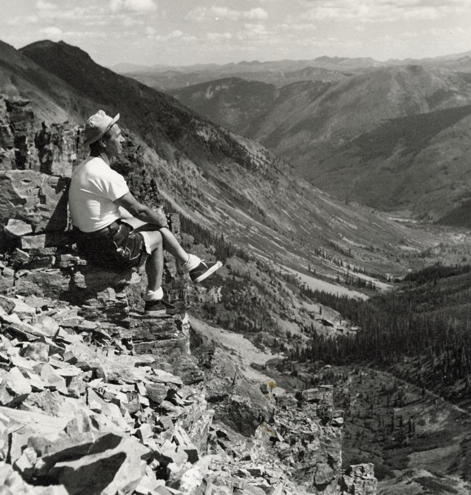
Herbert Bayer in the mountains around Aspen, August 1948; photo by Patrick Henry; courtesy of Herbert Bayer Papers, Denver Public Library
Where’s Herbert?
Pinpointing the location of a 1948 photo of Herbert Bayer in the backcountry
During the development of the Bayer Center’s current exhibition, Sculpting the Environment: The Three-Dimensional Art of Herbert Bayer, co-curator Koko Bayer pulled a 1948 photo of a smiling Herbert Bayer perched on an outcropping somewhere high in the Aspen backcountry. It would find a prominent place in the exhibition, communicating Bayer’s creative migration into outdoor sculpture and earthwork during his early years in Colorado.
But the exact location remained a mystery. Koko tried to match it to digital maps of areas around here. Hikers on the Bayer Center team and their friends tried to identify the mountains in the photo and the small structures visible in the valley below Bayer (who apparently, impressively, scaled mountains in sneakers). We didn’t find a definitive answer by the time we opened the show in June, and had been thinking it might be near Independence Pass and above an abandoned mill site there.
Then, in late August, we welcomed 45 teachers from Roaring Fork High School, including social studies teacher Howie Kuhn. As I walked teachers through the exhibition, I noted the photo and that we believed it was near Independence Pass. Howie kindly pulled me aside later and shared that he has been to the spot where Bayer is sitting.
According to Howie, Bayer is perched on a rock outcropping up the Castle Creek Valley exactly HERE at 38.99968, -106.84692. It is known as “Candle Peak,” its name inspired by the appearance of the sunrise from the area. Some miners called it “South Castle Peak” when they patented their claims, but neither of these names were codified by the U.S. Geological Survey.
The industrial structures visible in the valley below are the Montezuma Mill Site and Tramway.
The cabin visible further up the valley closer to where Bayer sits is Billy Tagert’s hut, which Bayer is known to have visited, long before it was converted into the A-Frame known as the Tagert Hut today, part of the publicly accessible Braun Hut System.
Howie, who lived up the Castle Creek Valley for three-plus years at the Aspen Center for Environmental Studies’ historic Toklat site before becoming a classroom teacher, knows the area intimately. He noted some additional landmarks in the photo that confirm its location: Ashcroft Mountain has a very characteristic domed profile; the forested Green Mountain is obscuring the lower flanks of Ashcroft Mountain; and the sub-peak of Slate Mountain — which would later be renamed Malemute Peak in honor of Stuart Mace — is visible on the left side of the image.
Mystery solved. Thank you, Howie!
Andrew Travers is the Penner Manager of Educational Programs
more


